(OARS “Rim to River” guided tour puts the unparalleled experience of hiking down to the bottom of the Grand Canyon – 7 miles by the South Kaibab Trail, and a full mile in altitude – within reach. After hiking the spectacularly scenic 7-mile South Kaibab Trail, and overnighting at the historic Phantom Ranch, we depart for our hike back up to the South Rim on the Bright Angel Trail Our adventure continues from 4/1, 4/8, 4/15 columns).)
We’ve been up since 5 am and had breakfast at the Phantom Ranch’s canteen at 5:30 am. As we head out, at about 7 am, the rain has subsided but the Colorado River that was a rich emerald green yesterday afternoon has become a muddy red-brown color.
I love the fact that we are making a loop and taking a different trail back up to the South Rim.
The Bright Angel Trail is a very old route that was used by many Native American tribes. They most likely used the trail to track animals and descend to their farms at Indian Gardens – a kind of oasis nestled between canyon walls (and visible from the South Rim) – where they cultivated such crops as corn, beans and squash. In the late 1800s, pioneers built a trail to reach mining claims in the canyon, some of which we can see as we hike. One of these miners was Ralph Cameron who soon realized that he could make more money from charging tourists a fee to hike the trail than from mining ore. He lengthened the Bright Angel Trail to the river and began charging a $1 toll. Over the years there was much controversy about the use of the trail until it was finally transferred over to the National Park Service in 1928.
It is mostly drizzling or raining for our 10-mile hike up the Bright Angel Trail, but it doesn’t bother us at all, especially since it is relatively comfortable temperature on this October day, on one of the last hikes of the season (the temperature can go over 100 degrees at the bottom of the canyon in the blazing sun of summer.)
We come upon what should be a trickle of water that has become a fast-moving stream with last night’s rain. Ryan lays down some rocks for us to scamper across, but I am still intimidated by the rushing water. Jonathan even offers to carry me across but I take off my boots and socks and walk across. The next two streams I cross by walking across rocks.
The Bright Angel Trail is not as steep as the South Kaibab Trail, but is longer, at 10.3 miles, and the route goes up constantly, almost never leveling off.
As the OARS people note, hiking uphill and downhill presents two very different physical challenges for your body. Hiking down into the canyon actually feels “easier” than hiking uphill because gravity is naturally propelling you downward. But there are actually punishing consequences for your lower body that accumulate gradually over the long descent. The combination of your legs holding back your body weight and the pressure from stepping down and across many log “stairs” create great strain on leg muscles, knees, ankles and feet.
Hiking out of the canyon, though, is more of a major cardiovascular workout, really working your heart and lungs in addition to your legs as you ascend nearly a vertical mile from the river to the rim. And even though our packs are only a fraction of the weight of the other hikers because OARS puts all but what we need for the hike on the mule to carry up for us, you feel the weight of everything you are carrying. I think myself clever for taking my Canon G16 instead of the much heavier Nikon 300 SLR. Again, the hiking poles make it much easier because you use your upper body in addition to your legs, relieving some of the strain on your knees. Still, we all came out of this much stiffer and more sore than the descent (amazingly, the stiffness is relieved by walking).
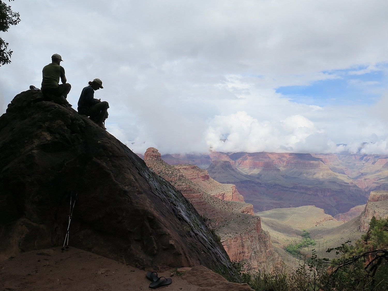
Because of the weather, the hike up presents moody scenes – fog, darkened colors – that match the strain. Everyone agrees that the clouds, rain and cooler temperatures are preferable to having unrelenting sun and heat for the ascent. Also, because you are walking up, you are constantly facing the hill, rather than the view. And the Bright Angel Trail is essentially nestled in a canyon between massive walls of rock, unlike the South Kaibab Trail which is steeper, but affords those epic views of the Canyon, and am so happy that OARS organizes the trip so we take the South Kaibab Trail down and the Bright Angel back up.
All of this means that I am really focusing on putting one foot in front of another, and looking more intently at the rocks and plants that are close at hand, every so often turning round to see the view behind.
I’m in the rear with Ryan, who does this hike in flipflops, mostly along the rocks that line the trail, skipping along them as sure-footed as a mountain goat – it’s uncanny. His knowledge of plants and rocks is astonishing. And when he describes them, he is like Hemingway (this is a guy who says he was considered a trouble-maker in elementary school; he tells us the story of how he once collected crickets to show the teacher but they all escaped, inciting the teacher’s ire.) That’s what the hike does – you wind up sharing such stories.
I look up at a black sheen on a sheer rock face. Ryan says that is “desert varnish” – a chemical reaction to water interacting with the rock.
The amazing thing is how we can see the different layers as we hike – like floors you pass in an elevator. Ryan announces them as we go. He has a mnemonic device to remember the geology of the rock layers in the Grand Canyon: Know the Canyons History Study Rocks Made by Time:
Know – Kaibab Limestone
The – Toroweap Formation
Canyon’s – Coconino Sandstone
History – Hermit Shale
Study – Supai Formation
Rocks – Redwall Limestone
Made – Muav Limestone
By – Bright Angel Shale
Time – Tapeats Sandstone
Ryan points out the “Great Unconformity” – a 1.2 billion year gap in time. This is a mind-boggling concept that stops me in my tracks (perhaps an excuse to take a bit of a rest). This is a “non-layer” which describes an age in which no sediments have been found. It is indicative of a time when an advancing sea eroded away the sediments that should be here to complete the record, notes say.
We left the camp at 7 am and at 10:15 am, get to the rest area at Indian Gardens, 4.8 miles from the start of the Bright Angel at Phantom Ranch.
Indian Gardens is like a lush oasis nestled between towering canyon walls – a relatively flat area that can be seen easily from the South Rim. Indians farmed here, cultivating corn, beans and squash. There is water here, toilets and a campground.
We press on.
We are amazed by the diversity of the plant life – there are 1800 species of plants in the Grand Canyon, Ryan says. That’s because of the different climates and because this is one of the only places in the Southwest with consistent water.
Ryan points out Sacred Datura (“Angel Fire”). a plant that yielded a ceremonial drug used by Native Americans. It has a dark green leaf but produces “an amazing pure white flower that blooms at night. Once the sun goes down, you can watch it open.”
Also, Agave that looks like a tall stick, also known as a century plant that takes 10-15 years to bloom. Once the bloom dies, the plant dies but it reproduces by its roots.Knowing the plant would die once it blooms, so just before it bloomed and would have died anyway, the Indians would collect the “heart” because was very sweet and had all the nutrients.
Along the way, Ryan points out Pale hoptree which has a citrusy fragrance (Ryan calls it skunky) but has a sort of seasoning scent that makes me want to cook with it (not sure if it’s poisonous or not). Also, Prickly pear cactus, Lemon verbena-bush, Sand verbine which has a tiny white flower that reminds me of a dandelion.
It feels like you are in Jurassic Park – very primordial.
At three miles from the top there is another rest area, and one of the prettiest views from the Bright Angel Trail back into the Canyon. The rock formations look to me like Mayan pyramids.
Because of the easy access to the Bright Angel Trail from the village at the South Rim, it is the most hiked trail in the country, Jon says, and this three-mile section is really busy with people who make it down for the 3 miles and then return.
I must say I get tired at the last 3 miles, then the last 1.5 miles, but push on. And this is where it gets interesting. This part of the hike is really about the physical challenge and mental focus, as opposed to the landscape. Looking up, there is still another high wall of switchbacks to hike.
It’s only 2:45 in the afternoon (not 4 or 5 pm as we expected) when we take the final steps of our 10.3 mile journey from the river to the South Rim. Taking those last steps, it feels like you have been instantly deposited by time machine from the primordial into civilization. There is momentary culture shock.
But there is also the feeling of pure exhilaration of accomplishment, of overcoming whatever personal demons or surmounting some inner goal, of being a participant, not just a spectator amidst this incomparable scenic beauty. I look around at the crowds of tourists looking over the Rim, recognizing that they can’t possibly see or appreciate the full depth and breadth of the Canyon, and just a little disappointed that they likely do not appreciate how our tiny band has by virtue of making it down are now part of the elite 1% Club.
We are fairly ragged but elated and we pose for photos around the “Bright Angel Trail” stone marker.
Next: Grand Canyon National Park’s South Rim
OARS’ 4 Day Grand Canyon Rim to River Hiker is offered April through October. The trip meets up and departs from the DoubleTree by Hilton, Flagstaff, Arizona. Prices range from $1499 to $1649, based on double occupancy, single supplement $200. See: www.oars.com/grandcanyon/hiking/grand-canyon-hiking.html
Contact OARS, Angels Camp, CA, 800-346-6277, 209-736-4677, oars.com, info@oars.com.
__________________
© 2016 Travel Features Syndicate, a division of Workstyles, Inc. All rights reserved. Visit goingplacesfarandnear.com , www.examiner.com/eclectic-travel-in-national/karen-rubin,www.examiner.com/eclectic-traveler-in-long-island/karen-rubin, www.examiner.com/international-travel-in-national/karen-rubin and travelwritersmagazine.com/TravelFeaturesSyndicate/. Blogging at goingplacesnearandfar.wordpress.com and moralcompasstravel.info. Send comments or questions to FamTravLtr@aol.com. Tweet @TravelFeatures. ‘Like’ us at facebook.com/NewsPhotoFeatures